It is encouraging to receive questions from our extended McCollough family. Some are easily answered and others require some study. For many years I have corresponded with Susan McClain, a descendant of Captain John McCollough and superb genealogist. We have collaborated to solve the mysteries of our McCollough, Spangler, and Fiscus roots using our DNA results and traditional paper genealogy records. Recently Susan posed the question, “How do you think the early settlers came up from Greensburg to the Chicora area, i.e., what route did they take? Would they have followed the Forbes Road to the Allegheny River or was there a more direct route overland to the Freeport area (like today’s Route 356)? Would they have followed Buffalo Creek from Freeport up to Chicora? I know you mention Indian paths in the book.”
Captain John McCollough and his Spangler and Fiscus relatives were no strangers to the western Pennsylvania wilderness. Many of the early settlers of Westmoreland County, like Captain John and his uncle Abraham Fiscus, served as “woods rangers” on scouting missions into this territory during the Indian Wars in the 1790s. No one settled in the “Indian Country” north and west of the Allegheny River. Land surveyors ventured into the area at their own peril, but it was not until Pennsylvania purchased northwestern Pennsylvania from the Indians in 1795 that settlement could take place. For years, the western side of the of the Allegheny River was known as the “Indian side.”
By 1795, there were woods roads or wagon trails connecting the settled areas around Greensburg and Hannastown where John McCollough and Elizabeth Spangler grew up. Outpost forts marked the western perimeter of the settled area. Captain John Craig established Reed’s Station on the Allegheny River and a blockhouse on Buffalo Creek at present day Freeport. Two other forts, Nicholson’s and Green’s, were along the Allegheny between Freeport and Kittanning. Kittanning was the site of a large Indian village and strategic crossing location on the Allegheny River. Fort Armstrong was built there in the French and Indian War, but it was long-been abandoned by the 1790s.
The danger of Indian attacks abated after the Treaty of Greenville in 1795 that resulted in the purchase of lands northwest of the Allegheny River from the Indians. After the Revolutionary War, Pennsylvania designated some of these lands in the Buffalo Creek watershed as “Depreciation Lands”, to be made available to veterans in payment for their military service in the Revolution. Other lands in the “Struck District” were opened for general settlement.
In 1795, Adam and John Hemphill, Jacob Barnhart, Sr., and Jacob Barnhart, Jr. made the first settlement on the headwaters of Buffalo Creek near Millerstown (Barnhart’s Mills, Chicora). A man named Spangler was already living in this area. This was most likely our ancestor John Spangler, John McCollough’s new father-in-law who started to make improvements on the McCollough farm in about 1795-96. In 1796, John McCollough and his Spangler relatives warranted land a few miles away on the headwaters of Sugar Creek. John McCollough and Elizabeth Spangler were married in 1797. The McCollough Monument on Oak Road in Chicora indicates they established their homestead the same year. How did the Westmoreland settlers get themselves, their livestock, food stores, and belongings to this remote wilderness on the headwaters of Buffalo and Sugar Creeks?
Indian paths crisscrossed the region, generally following the hilltops and avoiding the rugged bluffs and deep stream valleys. These paths were travelled for millennia, and evolved into the most logical and efficient way to navigate through the rugged hills of western Pennsylvania. Hundreds of years later they became the roads, highways, and turnpikes that we travel on today. One well-worn path can still be seen today on the west side of Captain John McCollough’s original farm. John McCollough knew these paths from his years scouting the frontier during the Indian Wars, but they were hardly large enough to pass wagons.
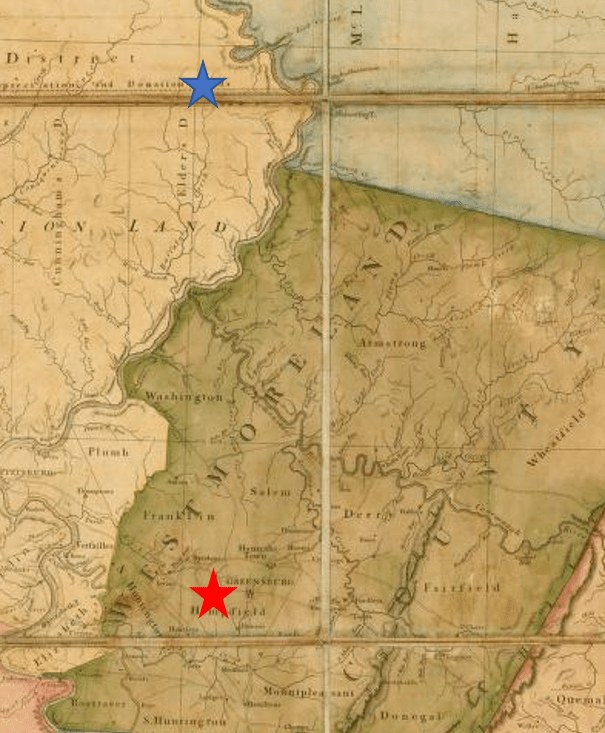
It is about 58 miles between the Fort Allen, Hempfield Township near Greensburg, PA to the McCollough farm near Kepples Corners, Chicora, PA. The McColloughs, Spangers, Barnharts, and Hemphills likely traveled one of two routes – northwest to Freeport and Butler and then northeast to Chicora or north to Kittanning and northwest to Chicora. The earliest maps of western Pennsylvania hold clues to the most likely routes taken by our McCollough and Spangler ancestors.
The Freeport travel route is unlikely for several reasons. By 1796, there was an early woods or wagon road from Greensburg to Freeport that followed an Indian trail that paralleled the Kiskiminetas River (now Routes 356 and 66). Settlers crossed the Allegheny River by ferry to Freeport, which quickly grew to a village and hub for developing the new territory. Many Westmorelanders settled southern Butler County via Freeport, including Sarver’s Mill (where I grew up!).
Traveling up Buffalo Creek from Freeport to its headwaters would seem a logical route for the McColloughs and Spanglers, but the Buffalo Creek watershed between Freeport and Chicora is rough country. Even today, there are no direct roads connecting these towns. This is why the Indians chose to travel north along the hills above the east side of the Allegheny River.
Nor was it likely that our McCollough and Spangler ancestors traveled to Chicora by way of Butler in 1795-97. The first settler in Butler was in 1803. The following year, the new Butler County Commissioners contracted to have two roads “viewed” (surveyed) from Butler to Freeport and from Butler to the mouth of Bear Creek (Lawrenceburg, Parker, PA, the location of an important salt works). The Butler-Freeport Post Road (now Route 356) and the Butler-Parker roads (now Routes 68 and 268) were not roughed out until about 1806-07, too late for our ancestors to use in 1795-97. The 1883 History of Butler County said that until about 1807, there was no road from Butler to the Sugar Creek Catholic Church in Armstrong County near the McCollough farm. “There was a mere path through the woods and over the hills that could only be traversed by packhorses.” A wagon road would not be developed for a few years. Thus, it is unlikely that our McCollough and Spangler ancestors traveled the Freeport-Butler route. The 1895 Butler County History indicated, “those who traversed the county as late as 1821 say that most of the roads then afforded very poor facilities for travel.”
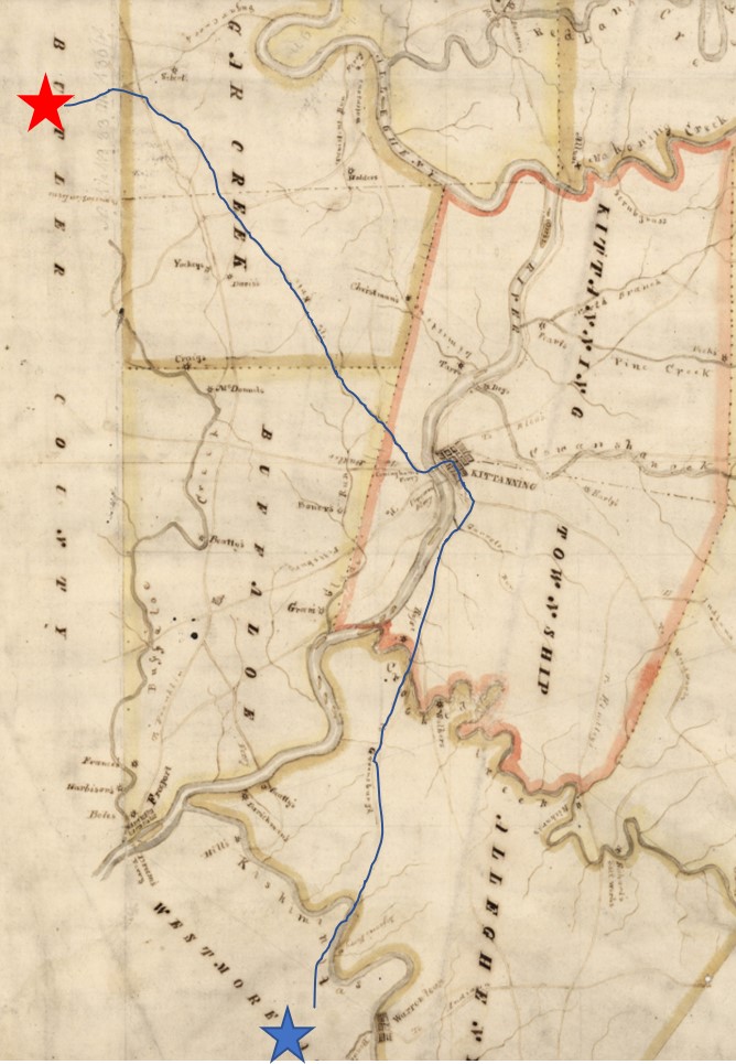
The route north from Greensburg to Kittanning to Millerstown/Chicora was the most likely path used by our McCollough and Spangler ancestors and the other early settlers of northern Butler County. The first leg of their journey was on the road to Freeport to Salem Crossroads (now Delmont, PA). From there a heavily traveled path traveled northward. It would eventually become the Greensburg-Kittanning Pike (now Route 66) that was built around 1800. This route quickly widened to become a wagon path to carry the stream of Westmoreland settlers into the new lands available in northeastern Butler County. It required fords across the Kiskeminetas River and Crooked Creek until it came out of the virgin forest at the small settlement at Kittanning on the east side of the Allegheny River.
The final leg of the journey was to cross by ford or ferry across the Allegheny River at Kittanning to access the Kittanning-Brady’s Bend Road. This woods road led northwest to the headwaters of Buffalo and Sugar Creeks. Eventually, this heavily-travelled path became a road that ran past John and Elizabeth McCollough’s farm. Today it is known as the “Kittanning Road” (now Routes 68 and 268). The McCollough farm was strategically located at the intersection of the Butler-Parker Road constructed by Butler County and the Kittanning-Brady’s Bend Road built by Armstrong County. The two roads meet at Kepples Corners, the northeast corner of Captain John McCollough’s farm. Perhaps John was instrumental in influencing the road commissioners of both counties to establish these roads bordering the north and east sides of his farm. These roads were strategic for selling and transporting goods from his farm and pottery to Butler (14 miles southwest) and Kittanning (17 miles southeast).
Today you can retrace the steps of our ancestors on Google Maps or by car. Start at the Fort Allen memorial east of Greensburg and see John Spangler’s name on the monument of early settlers near the Harrold Zion Lutheran Church. Historic Hanna’s Town and the Westmoreland Historical Society are nearby. Follow Route 66 north to Kittanning. Bushy Run Battlefield and museum are fascinating detour along the way. In Kittanning, turn west and cross the river on Route 268. Before you do, you may want to visit the McCain House and the Armstrong County Historical Museum. Continue to follow Route 268 into Butler County and conclude your journey at Kepple’s Corners. You can buy an ice cream cone and walk out back to visit the McCollough (Hillview) Cemetery. Here you can find Captain John McCollough’s large obelisk tombstone (and the graves of many of our early ancestors). You are now standing in the northeast corner of Captain John McCollough’s homestead farm. The McCollough Monument is on nearby Oak Road.